Droneradar Apk is a mobile application that offers the best user experience for pilots and aircraft. A solution that gives you all the information you need in one place, regardless of the size of the drone. Integrated with the PansaUTM system you can quickly and easily check information about where you can fly and the rules that apply. It offers a great user experience and makes the process of getting a pilot certificate easy and fun. For the best use, follow the instructions of the airline services.
It is the official application that allows drone operators to navigate the complex maze of aviation regulations. The application is included in the PansaUTM, which is managed by the Polish Center for Aeronautical Services. The application is supported by the Polish Civil Aviation Authority (ULC). The Droneradar App allows you to search locations by address.

About Droneradar APK
Droneradar APK is a powerful and essential tool for drone operators in Poland, offering a user-friendly interface to navigate the complex world of aviation regulations. Developed in collaboration with the Polish Air Navigation Services Agency (PANSA) and supported by the Polish Civil Aviation Office (ULC), the app is integrated with PansaUTM, a system that manages unmanned aerial vehicle (UAV) operations within Poland’s airspace.
It provides real-time information and guidance to ensure that drone flights are conducted safely and by national and international laws.
Features of Droneradar APK
Droneradar APK is designed to assist drone operators, whether they are hobbyists or professionals, by providing comprehensive, real-time information on airspace regulations and flight permissions. The app ensures compliance with local regulations and supports safe drone operations by offering several key features:
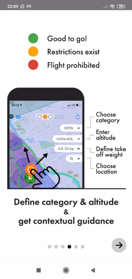
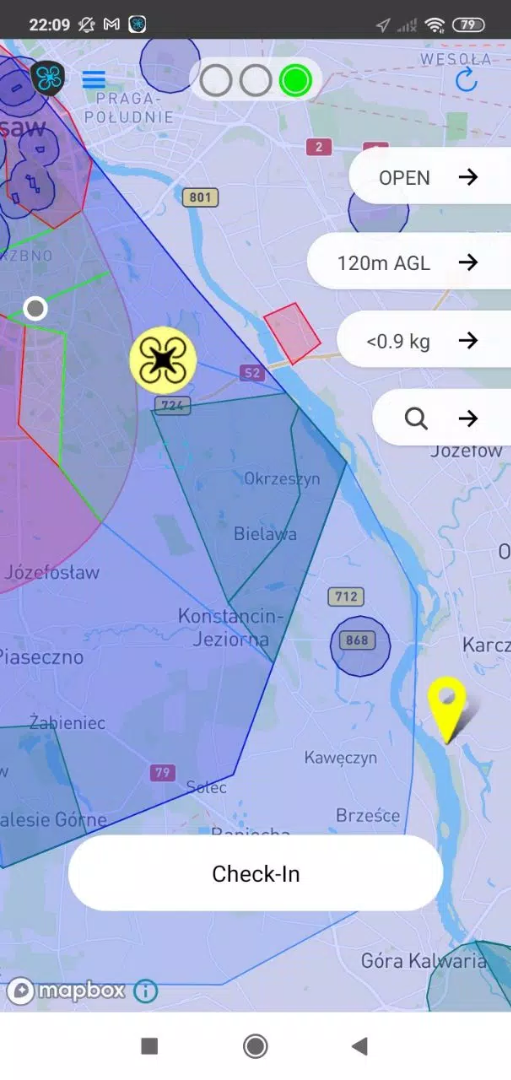
Real-Time Airspace Status Updates: It provides up-to-date information on airspace restrictions and permissions. The app uses a simple color-coded system to indicate the current status of the airspace:
- Green: Indicates that the area is clear for flight. Operators can fly their drones up to the maximum allowable altitude, typically 120 meters (approximately 400 feet) AGL (Above Ground Level), without additional restrictions.
- Yellow: Signals that there are restrictions in place. By clicking on the signaler icon, users can access detailed information about the specific restrictions and obtain contact details for airspace managers.
- Red: Indicates that drone flights are not permitted in the area.
Flight Check-In and Registration: To enhance safety and coordination among airspace users, Droneradar APK allows drone operators to check in their flight locations. This feature requires users to enter contact details and information about their drone, including the type and model. The flight check-in is crucial as it marks the drone's operating area on the Droneradar map, informing other users and airspace managers about ongoing UAV activities. This transparency helps prevent conflicts and ensures the safety of all airspace users.
Integration with PansaUTM: The application is integrated with the PansaUTM system, which PANSA administers. PansaUTM provides a centralized platform for managing UAV operations, ensuring that all drone activities are coordinated with manned aviation. This integration allows Droneradar to offer precise, real-time data on airspace availability and potential hazards, enhancing situational awareness for drone pilots.
Notifications and Alerts: The app features a robust notification system to keep users informed of any changes in airspace status or new regulations that may impact their operations. Enabling notifications is crucial for maintaining awareness of dynamic airspace conditions and ensuring compliance with current regulations.
Location-Based Services: To provide accurate and relevant information, Droneradar requires users to enable location services on their mobile devices. This feature allows the app to provide specific guidance based on the user’s current location, ensuring that drone operators are always aware of the regulations that apply to their immediate surroundings.

Ensuring Safe and Compliant Drone Operations:
Operating a drone, whether it is for recreational or commercial purposes, comes with a set of responsibilities. Droneradar APK helps operators meet these responsibilities by providing critical information on airspace management and regulatory compliance. Here are some important guidelines that all drone operators must follow:
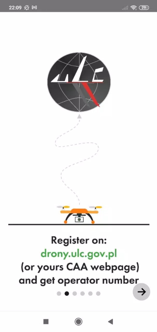
Registration: If you are flying a drone weighing over 250 grams or any drone equipped with a camera, you must register with the Civil Aviation Authority (CAA) via the website drony.ulc.gov.pl. Once registered, operators should enter their Drone Operator Registration number into this APK during the flight check-in process.
Visual Line of Sight (VLOS): Operators must always maintain a visual line of sight with their drones. This rule ensures that drone pilots can see and avoid other aircraft, people, and obstacles.
Altitude Restrictions: In the Open category, drone flights are limited to a maximum altitude of 120 meters AGL. This restriction helps prevent conflicts with manned aircraft, which typically operate at altitudes above 150 meters AGL.
Liability Insurance: While not mandatory, it is strongly recommended that drone operators purchase liability insurance. This insurance protects against potential damages or accidents that may occur during drone operations.
Awareness of Air Structures: Drone operators must be aware of existing air structures and the presence of other airspace users. It provides an easy and efficient way to check if the area is clear for flight or if there are restrictions or hazards present.

Conclusion
Droneradar APK is an invaluable tool for drone operators in Poland, providing real-time information and guidance to ensure safe and compliant UAV operations. By integrating with the PansaUTM system and being supported by the Polish Civil Aviation Office, it offers a comprehensive solution for navigating the complex regulations governing drone flights. Whether you are a hobbyist or a professional drone pilot, Droneradar APK equips you with the knowledge and tools needed to operate safely, legally, and responsibly in Poland's airspace.


